Transportation & Parking
Out-of-state hikers who come to Georgia will probably arrive in either Atlanta or Gainesville, GA. Gainesville, about 50 miles northeast of Atlanta, is the closest town to the trail served by public transportation. Amicalola Falls State Park is about 38 miles from Gainesville.
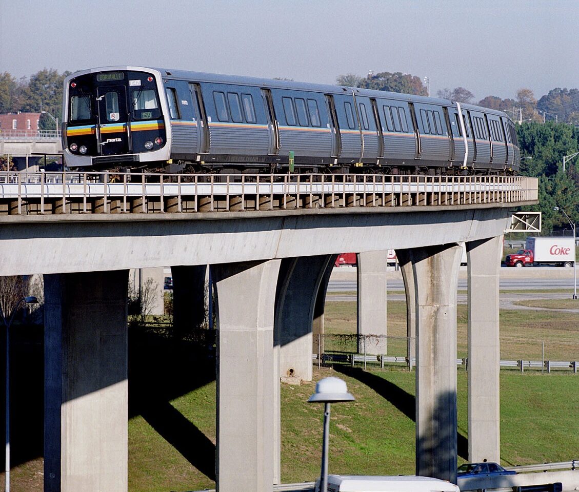
If you are going to arrive at the Hartsfield-Jackson Atlanta International Airport, make an advance reservation with a shuttle service (see below). The shuttle may pick you up at the airport or have you take public transportation (MARTA) from the airport to a station outside the city. This is easily done since there is a MARTA train station in the airport terminal.
The MARTA station farthest north from the airport is North Springs station which has no easy access to shopping. One stop earlier, at the Sandy Springs station, there is shopping nearby, including an REI, Target and many restaurants and shops.
If you are traveling by train or bus, you may arrive in Atlanta or Gainesville. Again, you will need a shuttle to the trail or Amicalola Falls State Park. Be sure to make a reservation for a shuttle.
Shuttle Sources
Lists of shuttle operators along the Appalachian Trail are maintained on the following websites:
Directions
If you decide to travel between Gainesville and the Atlanta Airport, AMTRAK and Greyhound Bus Lines operate connecting services. The easiest and least expensive way to get from Hartsfield-Jackson Atlanta International Airport to the bus station in downtown Atlanta, or to the Amtrak station in Midtown Atlanta is to use the Atlanta public transportation system, MARTA (Metro Atlanta Rapid Transit Authority).
By Greyhound Bus
Atlanta Bus Station
232 Forsyth St
Atlanta, GA
Atlanta Airport to Atlanta Greyhound Depot:
- Take the MARTA train from the airport to Garnett Station (S1).
- Go out Garnett Station, turn left to Forsyth St. The bus depot is to your right on Forsyth St.
- OR take Atlanta Airport Shuttle bus to bus depot.
- OR take taxi to bus depot.
Call Greyhound at 1-800-231-2222 or log on to their website to confirm the latest schedule and fare information.
By AMTRAK Train
AMTRAK Train Station
188 Peachtree St.
Atlanta, GA
Atlanta Airport to AMTRAK station:
- Take MARTA train to Arts Center Station (N5).
- Transfer to MARTA bus #110 at the Arts Center Station; or walk to left uphill on 15th Street to Peachtree Street and walk one mile north (left) on Peachtree Street to AMTRAK station.
- The small AMTRAK station is on your left just after crossing over Interstate 85 on Peachtree Street.
- OR take Atlanta Airport Shuttle bus to AMTRAK station.
- OR take taxi, Uber or Lyft from airport to AMTRAK station.
Call AMTRAK at 1-800-872-7245 or log onto their website to confirm the latest schedule and fare information.
MARTA bus routes and schedules are subject to change. Verify all information directly with MARTA prior to planning your trip at their website.
The Hartsfield-Jackson Atlanta International Airport website also maintains a list of shuttle provider services connecting the airport to Dahlonega, Dawsonville and Gainesville, Georgia, the towns nearest to the southern terminus of the A.T..
Approach Trail To Springer Mountain
Many hikers start their thru-hike at Amicalola Falls State Park on Georgia Highway 52 between Dahlonega and Ellijay and hike the 8.8 mile blue-blazed Approach Trail to Springer Mountain. At the peak of thru-hiker season, from mid-February through April, GATC has a base camp set up at the Visitor Center in Amicalola Falls State Park where hikers can be assisted in preparing for departure on the hike of their dreams.
Driving to the Approach Trail
The easiest route from the Atlanta area to Amicalola Falls State Park is Interstate 75 North to  Interstate 515 North to Ellijay, then Georgia Highway 52 east to Amicalola Falls State Park.
Parking is available in the park near the visitor center with spaces for 50-plus vehicles. There is an entrance fee. If you want to leave a vehicle at the park while you hike, you must register your car at the visitor center. There is an additional fee charged for long-term storage.
Driving to the park from Dahlonega, Georgia (about 60 miles north of downtown Atlanta via GA Hwy. 400), take Georgia Highway 52 west approximately 20 miles to Amicalola Falls State Park.
GPS Coordinates: 34.557873, -84.249657
Driving to Springer Mountain
 The parking lot access for Springer Mountain is located on USFS 42 and can accommodate 20-plus cars. It is often full on weekends. The permitted length of parking there is 14 days.
The shortest approach involves driving north of Springer to where the A.T. crosses USFS Road 42, then hiking south on the white-blazed A.T. one mile to the summit of Springer Mountain. Note that you cross USFS 42 and follow the white blaze trail south to the summit before backtracking to the parking area and on northward.
Preferred Route
From Georgia Highway 52 in Cartecay (12.1 miles west of Amicalola Falls State Park or 7.4 miles east of Ellijay), turn on Roy Road between the Methodist Church and Stanley’s Grocery and go 9.7 miles to the end of the road.
Turn right onto Doublehead Gap Road and go 2.2 miles to Mt. Pleasant Baptist Church, each of which are paved.
Turn right onto the gravel USFS Road 42 and go 6.8 miles to the parking area on the left side of the road. To reach Springer summit, cross the road and follow the white blazed trail southbound.
Alternate Route
From Georgia Highway 52, 9.5 miles east of Amicalola Falls State Park or 8.5 miles west of Dahlonega, turn left traveling east or right traveling west on Highway 52 onto Nimblewill Church Gap Road.
Go 2 miles and turn right on USFS Road 28. Watch for a sign that points to Georgia Wildlife Management Area on the left and a sign to Jones Creek Road on the right.
After 2.2 miles, bear left at the fork onto USFS Road 77 and go 5.1 miles.
Take a hard left onto USFS Road 42 and go 2.7 miles to A.T. You will pass a Benton MacKaye Trail crossing (white diamond blazes). The Springer Mountain parking lot is on the right side of the road. To reach Springer summit, cross the road and follow the white blazed trail southbound.
NOTE: These Forest Service roads can be quite rough, and may be impassable by car or van in winter or very wet weather. Contact the Chattahoochee National Forest Toccoa Ranger District in Blue Ridge, Georgia (706) 632-3031 for current road conditions.
GPS Coordinates: 34.637512, -84.195343
Access & Parking along the Appalachian Trail in Georgia
The A.T. can be directly accessed from major paved road crossings in Georgia at Woody Gap (GA Hwy. 60), Neel Gap (US Hwy. 129/19), Tesnatee Gap (GA Hwy. 348), Hogpen Gap (GA Hwy. 348), Unicoi Gap (GA Hwy. 75/17) and Dicks Creek Gap (US Hwy. 76).
Vehicles may be parked along USFS roads or parking areas for a maximum of 14 days. Vehicles should never obstruct the roadway. Vehicles may not park on trails, on trailhead entrances or in front of USFS gates. Drivers should be extra vigilant about leaving a clear passage for large emergency vehicles in the event of fire or search and rescue efforts. Vehicle owners who violate USFS orders and laws could be subject to fines and/or having their vehicle towed.
The Woody Gap parking area is on both sides of GA Hwy 60 and has space for 20+plus cars. Both parking areas are often full on weekends. Bathrooms and garbage cans are located on the northbound side. Note: Because the Woody Gap parking area is so popular, USFS has proposed a daily parking fee projected for some point in 2024.
- GPS Coordinates: 34.677589, -83.999931
- what3words: tinfoil.escape.power
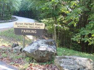
The parking area for hikers accessing the A.T. at Neel Gap is located off US Hwy 129/19 at the Byron Herbert Reece parking area, located 0.2 mile north of Neel Gap and Mountain Crossings. From the parking lot, the A.T. is reached by a 0.7-mile side trail. A maximum of 38 vehicles are allowed to park at Byron Herbert Reece. Because this parking area provides day hikers with the good access to Blood Mountain, it is often full on weekends.
- GPS Coordinates: 34.741980, -83.922727
- what3words: huge.trapping.cheekbone
![]() Tesnatee Gap parking area has space for 15-plus cars. GA Hwy 348 is also known as the Richard Russell Scenic Highway.
Tesnatee Gap parking area has space for 15-plus cars. GA Hwy 348 is also known as the Richard Russell Scenic Highway.
- GPS Coordinates: 34.726109, -83.847549
- what3words: jaded.defended.tycoons
Hogpen Gap parking area has space for 20-plus cars. It is a short distance east of Tesnatee Gap.
- GPS Coordinates: 34.725403, -83.839165
- what3words: spree.gymnastics.pianist
Unicoi Gap parking area has space for 20-plus cars.
- GPS Coordinates: 34.801735, -83.742844
- what3words: informed.occupational.snappy
Dicks Creek Gap parking area has space for 14-plus cars. It is often used by shuttles picking up and delivering hikers to the A.T.
- GPS Coordinates: 34.912163, -83.618896
- what3words: fakes.munched.minibus
The Appalachian Trail in Georgia can also be accessed from several USFS gravel roads or side trails from recreation areas located at Springer Mountain, USFS 42; Three Forks, USFS 58; Hightower Gap, Rock Creek Road and USFS 42; Horse Gap USFS 42; Cooper Gap, USFS 15, USFS 42 and USFS 80; Gooch Gap, Cooper Gap Road and USFS 42; Dockery Lake Recreation Area, off GA 60/ Dockery Lake Trail; Lake Winfield Scott Recreation Area off GA 180 / Jarrard Gap Trail or Slaughter Gap Trail, Vogel State Park off US 129/19 / Bear Hair/Coosa Backcountry/Duncan Ridge Trails; Indian Grave Gap, Indian Grave Gap Road / USFS 283 (involves a water crossing.)
The A.T. can also be accessed from two USFS roads that are difficult to travel without a high clearance 4WD vehicle: Tray Gap, Tray Mountain Road, and Blue Ridge Gap, Blue Ridge Gap Road. Blue Ridge Gap is the last A.T. access by road in Georgia.
Note: Check with the Chattahoochee-Oconee National Forest for guidance related to off-highway vehicles (OHVs). Unless designated for OHV purposes, all USFS roads that are open to highway-legal motorized use are not OHV trails.
Disclaimer
The information provided here is subject to change and is beyond the control of the Georgia Appalachian Trail Club.