Trail Guide
A detailed guide book with maps of the Appalachian Trail is available from the Appalachian Trail Conservancy’s Book Store.
Multiple trailheads with parking offer access to the A.T. in Georgia. In addition to trailheads at the five major highways that cross the trail, the A.T. can be reached on several U.S. Forest Service roads. See Transportation & Parking for more information.
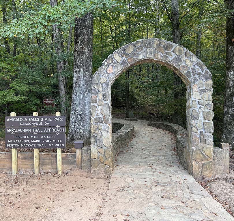
Approach Trail
The Southern Terminus Access Trail begins behind the Amicalola Falls State Park Visitor Center. This 8.8 mile, blue-blazed approach trail starts behind the Visitor Center and follows the Base of the Falls Trail climbing to the top of Amicalola Falls, crossing the lodge road, then climbing through the Amicalola Creek Watershed to Springer Mountain. Frosty Mountain is at mile 4.1 of the Approach Trail and Nimblewill Gap is at mile 6.0. A number of campsites and two shelters will be found on this trail. Water isscarce on the Approach Trail once you leave the park so be sure you have plenty before departing.
Hike Inn Trail
This 6-mile long trail parallels the Approach Trail, departing from it a short distance from the top of the falls and rejoining the Approach Trail a short distance from Nimblewill Gap. There is no camping along this trail, but snacks, drinks and water refills are available at the Len Foote Hike Inn for a donation.
Len Foote Hike Inn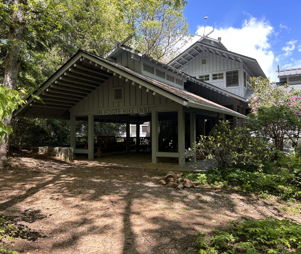
Georgia Appalachian Trail
Information stated here is subject to change. All information should be confirmed ahead of time. Last update August, 2023.
Download Trail GuideMiles 0 to 09.9
00.0 — Springer Mountain (3782 ft) is Southern terminus of the A.T. Bronze plaque on rock, sign and register nearby. Good views to west. Katahdin in Maine is 2,194 miles north via the white-blazed trail.
00.2 — Springer Mountain Shelter (3700 ft) to trail east on side trail with bearbox and privy and reliable spring. Established tent sites nearby.
01.0 — USFS Road #42 (parking). Kiosk with information.
02.8 — Stover Creek Shelter (2928 ft) with all-season stream nearby. Bearbox and privy, stream nearby. Located trail east off the A.T.
04.3 — Three Forks (2517 ft), where three streams converge to form Noontootla Creek, USFS Road #58.
05.2 — Blue blazed trail to Long Creek Falls. Worth a visit.
07.4 — Hawk Mountain Campsites (3222 ft) with tent pads, privy and water. Trail to trail west.
08.1 — Hawk Mountain Shelter (3145 ft) with bearbox, privy and water down path behind shelter. Limited camping outside shelter. Get water here when northbound. No water source until Justus Creek at mile 14.2.
08.6 — Hightower Gap (2852 ft), junction with gravel USFS Roads #42 & #69.
Miles 10 to 19.9
12.2 — Cooper Gap (2812 ft), junction with gravel USFS Roads #15, #42 and #80.
15.7 — Gooch Mountain Shelter (2767 ft) and bearbox and privy to left on short side trail. Excellent spring, tent sites.
16.9 — Gooch Gap (2816 ft), USFS Road #42 leads 2.7 miles to Suches, Georgia.
Miles 20 to 29.9
20.5 — Woody Gap (3164 ft), paved GA Hwy. 60 with good parking. Bathroom and garbage cans. Suches, Georgia is 1.9 miles to left.
21.9 — Big Cedar Mountain (3582 ft), with good views from rock ledges.
23.6 — Dockery Lake Trail junction (3046 ft); trail leads southeast to USFS camping on Dockery Lake; parking available.
23.9 — Lance Creek tent pads (2869 ft); tent pads and cables available for hanging food.
26.3 — Jarrard Gap (3284 ft), blue-blazed trail to left leads one mile to Lake Winfield Scott Recreation Area (USFS) and GA Hwy 180. Piped seasonal spring at head of blue-blazed trail. Between March 1 and June 1: USFS Camping Restriction from Jarrard Gap to Neel Gap. Bear canister required during the restricted period due to increased bear activity at this time.
27.7 — Woods Hole Shelter (3659 ft), privy 0.4 miles west on side trail. Water at mid-point on trail.
27.7 — Bird Gap (3,650 ft). Freeman Trail bypasses Blood Mountain summit and leads 1.8 miles to Flatrock Gap.
28.2 — Slaughter Creek Trail (3805 ft), blue-blazed to left leads 2.7 miles to Lake Winfield Scott Recreation Area (USFS). Stream at right turn is the last water before Neel Gap and is the water source for campsites ahead.
28.3 — Slaughter Creek Campsite (3874 ft), eight tent pads built on sidehill.
28.6 — Duncan Ridge Trail junction (4128 ft), blue-blazed to left connects to the Benton MacKaye Trail creating the Georgia Loop, 55 miles in length.
29.2 — Blood Mountain (4442 ft, highest point on the A.T. in Georgia). Blood Mountain Shelter with privy located on summit. Closest water is creek at A.T. and Slaughter Creek trail junction. Panoramic views in all directions.
Miles 30 to 39.9
30.6 — Flatrock Gap (3447 ft), Trail to Byron Reece Memorial, west .6 mi. Parking; Freeman Trail bypasses Blood Mountain summit and leads 1.8 miles to Bird Gap.
31.6 — Neel Gap (3100 ft), paved US 19/129 with parking at Byron Reese Memorial north on highway. Walasi-Yi Center has hiker supplies, equipment and hostel available on first come, first serve basis.
32.8 — Bull Gap (3642 ft), campsite with water 0.2 miles on side trail to west.
35.3 — Wolf Laurel Top (3763 ft), views to east in clearing.
37.6 — Tesnatee Gap (3140 ft), paved GA Hwy. 348 (Richard B. Russell Scenic Highway) with parking.
38.3 — Whitley Gap Shelter trail (3623 ft), shelter with privy is trail east 1.2 miles down trail; magnificent views in season, dependable spring.
38.5 — Hogpen Gap (3461 ft) on GA Hwy. 348 with parking.
Miles 40 to 49.9
43.3 — Low Gap Shelter (2966 ft), shelter, privy and water trail east via side trail into cove. Note: There is no food storage box at this location. Please hang all food properly. This is bear country.
48.3 — Chattahoochee Gap (3523 ft), spring trail east via side trail to headwaters of Chattahoochee River.
49.7 — Site of former Rocky Knob shelter. Area still usable as campsite. Spring downhill below old shelter site.
Miles 50 to 59.9
50.7 — Blue Mountain Shelter (3889 ft), privy via side trail to trail west. Spring on A.T. just before turnoff to shelter.
53.0 — Unicoi Gap (2940 ft), paved GA Hwy 75 with parking.
55.6 — Indian Grave Gap (3117 ft), cross USFS Road #79; Andrews Cove Trail leads trail north to Andrews Cove Campground (USFS)
56.7 — Cheese Factory campsite (3578 ft), several campsites with nearby water available.
57.4 — Tray Gap (3841 ft), junction with Tray Mountain Road (USFS Road #79).
58.2 — Tray Mountain (4398 ft) with outstanding views from summit. Descending to north, trail is rough, rocky and steep.
58.7 — Tray Mountain Shelter (4216 ft), shelter with privy is trail west via side trail, good spring downhill behind shelter.
Miles 60 to 69.9
64.2 — Addis Gap (3334 ft) campsite with stream to trail east 0.5 mile down old fire road.
65.2 — Kelly Knob (4144 ft), summit is 0.2 mile to trail west.
66.1 — Deep Gap Shelter (3554 ft), shelter and privy is 0.3 mile to trail east. Water in piped spring just before shelter.
67.1 — Vista side trail (3886 ft), beautiful view 0.1 mile to east – worth the side trip.
69.7 — Dicks Creek Gap (2654 ft), paved US 76 with picnic tables and seasonal stream.
Miles 70 to 79.9
74.2 — Plumorchard Gap Shelter (3008 ft), shelter with privy is located to trail east of gap, down side trail. Spring trail west near shelter.
78.7 — Bly Gap (3835 ft), near Georgia/North Carolina state line, is marked by gnarled oak tree and fine views to north. Good campsite and water to right below clearing.